
Are you using the power of maps and geotechnology to learn more about the world of your ancestors?
Geospatial information systems (GIS) are revolutionizing how we do family history research and understand our family’s landscape throughout history—they are now more powerful and easier to use than ever, so it’s a great time to get started. There are also more online historical maps available than ever before.
In part one of this two-part article, Google Earth for Genealogy, Part 1: Putting Your Ancestors on the Map, we became acquainted with Google Earth, a free, powerful, and easy-to-use GIS application.
We looked at how researchers can use Google Earth to put their own ancestors on the map and organize the information in their family tree in fascinating new ways.
In part two, we’re going to look at how we can import data created by others into Google Earth—digitized historical maps and other tools—and then use it to analyze our own family history in a geographic context.
But even if you aren't using Google Earth, these tools can be used with just a web browser and will still help your research.
This article will cover:
- How to determine if a historical map can be imported into Google Earth.
- How to import historical maps into Google Earth in a few easy clicks.
- Using Google Earth to look at New York county boundaries at any point in history.
- Using Google Earth to examine the topography of our ancestors.
- Using Google Earth to create eye-opening reconstructions of our historical urban neighborhoods.
Can I import this into Google Earth? The magic of georeferencing
As mentioned in part one, Google Earth’s default map interface displays a modern, satellite image of the earth and its contemporary locations.
Thanks to a process called georeferencing, we can download digitized historical maps and import them into Google Earth. If a digital map has been georeferenced, that means it’s been adjusted to fit precisely over a modern map of the earth.
When you load a georeferenced map into Google Earth, you’ll see it laid over the modern map interface, and you can easily toggle it on or off.
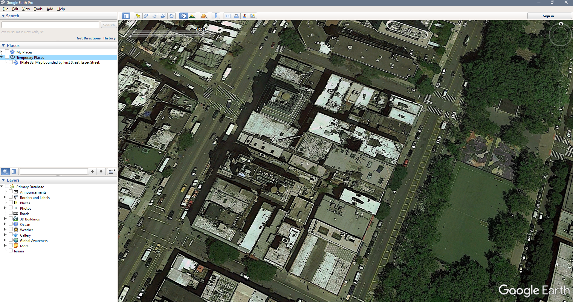
Here is an example of what the Google Earth map interface looks like without any imported historical maps:
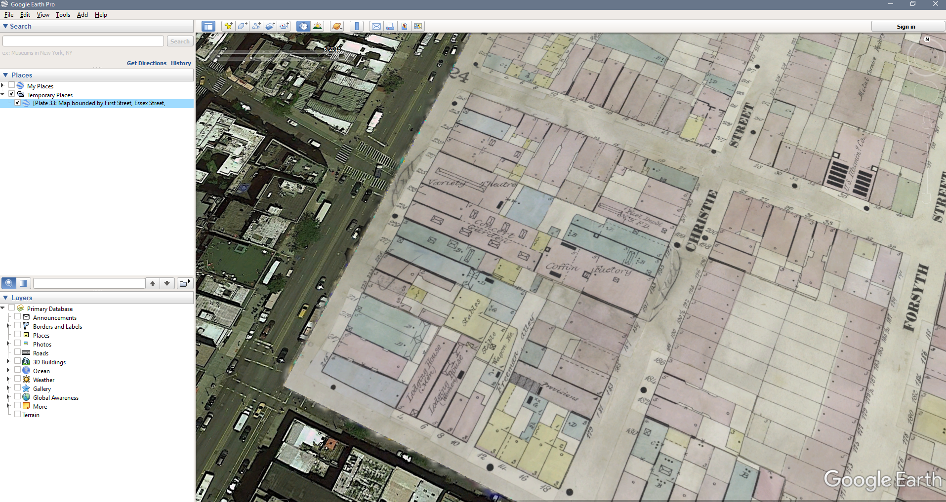
And here is what the same exact area looks like, with a georeferenced, digitized historical map loaded into the program:
Pretty amazing!
In general, the best way to determine if a digital map can be imported into Google Earth is to see if there is a version of the map available as a file that ends with the extension .kml or .kmz—these are two file formats that most GIS applications can load.
Import digital maps into Google Earth in a few clicks
Most operating systems will automatically associate .kml and .kmz files with Google Earth. This means you just need to download the .kmz file you’re interested in, locate it in your file browser, and double click to open it.
You may have another program on your computer that’s already associated with these kinds of files, so if that fails, you can always load the file using Google Earth. Open up the application, choose File > Open… and select the .kmz file you downloaded.
It’s that easy! Now let’s take at some specific and really useful things you can import into Google Earth that will help your New York genealogy research.
Look at New York county boundaries at any point in history
One challenge of New York research is that many of our ancestors populated the state while local, regional, and national territorial boundaries were evolving.
An ancestor could have lived in one county during one census, and another in the next census without ever having moved their residence—this makes looking for records challenging and creates the possibility that we may be investigating repositories in the wrong county.
The Newberry Atlas of Historical County Boundaries is the perfect tool to meet this challenge head-on.
A project of the Newberry Library in Chicago, this website is a fantastic resource for exploring the changing boundaries of counties in all 50 states. You can use the interactive map online to see borders of any county in the United States at almost any time in history.
The maps become most useful when they are imported into Google Earth—they can be downloaded as .kmz files and then added as a layer to your desktop application.
To do so, download the New York .kmz file and open it with Google Earth:
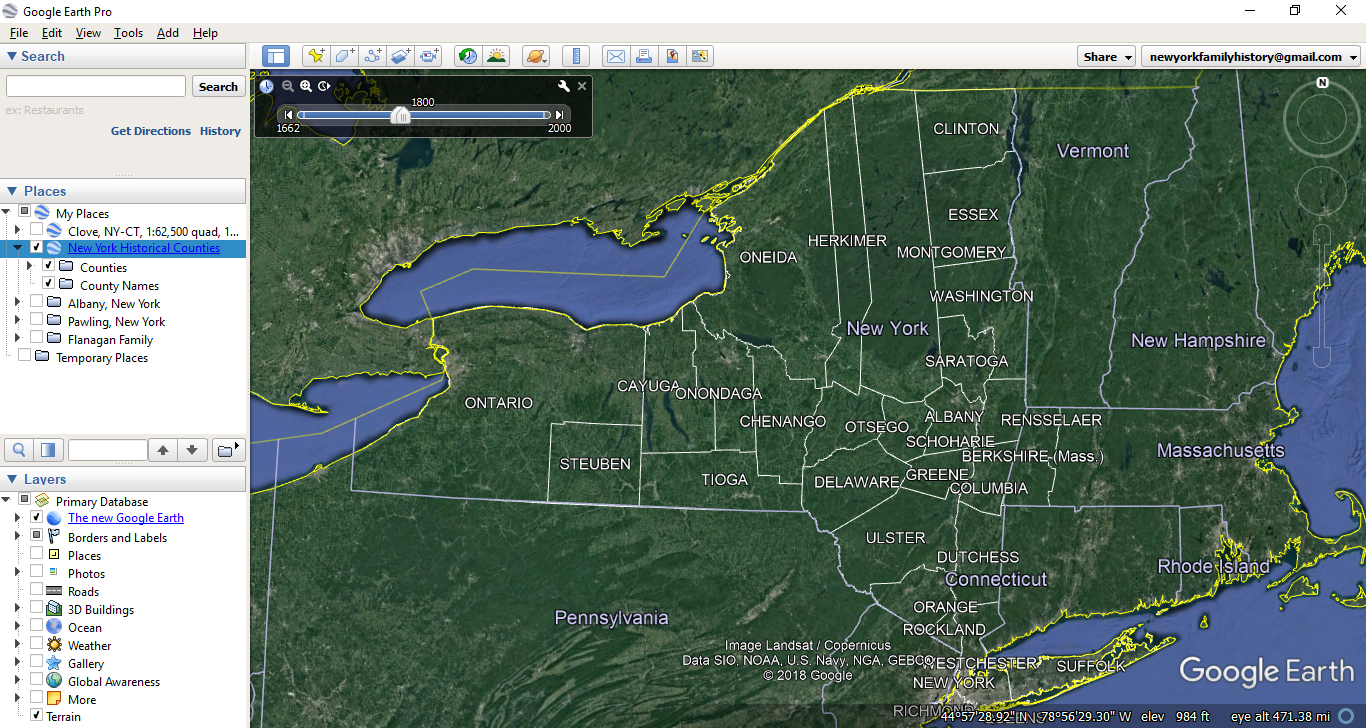
You’ll see the atlas get loaded into the program and will initially see the area’s earliest boundaries. You will also now see a horizontal scroll bar in the upper left-hand corner of the map interface. You can use this to adjust to the precise date you’re looking into and instantly see the state’s boundaries at that moment in time.
This is incredibly useful if you have added your ancestors and their life events to the map, as outlined in the first part of this two-part article.
Examine historical topography
Another type of georeferenced map we can load into Google Earth displays more than just borders.
Topographic maps use contour lines to show changes in elevation and display other features that help us form a picture of the landscape they represent. If you have never heard of a topographic map before, this short video explains what one is and how to read it.
Today, hikers and mountaineers are the main consumers of these maps, but they’re really useful for genealogists too. Remember that before cars became a common feature of life in New York, topography had a much bigger impact on our ancestors than it has on us today.
By examining the topography of your ancestor’s area you can make estimates about how they traveled around in their day-to-day lives, and where they may have generated records you can discover.
A fantastic collection of historical topographic maps can be found on a website created by the United States Geological Survey, USGS topoView. You can use this website to browse topographic maps from any location in the United States and choose what year to display.
Historical topographic maps can be found in many other locations as well—our guide to Historical Maps for New York Genealogy has a number of resources that contain these kinds of maps.
Each map can be downloaded as a .kmz file and easily loaded into Google Earth:
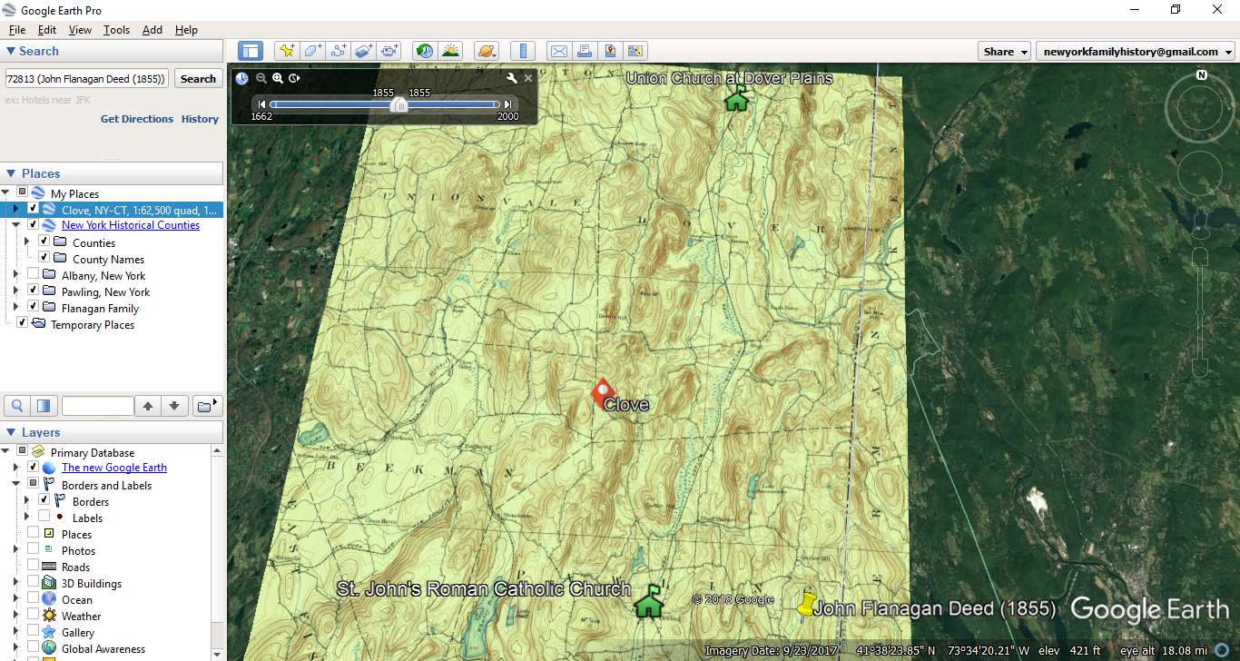
When combined with an ancestor’s historical address, this method will help you recreate the landscape of their lives in a very satisfying and informative way. The above image shows a location found in my own family history, along with the location of a potential religious congregation this family was a part of. Adding a topographic map to Google Earth will help me assess the probability this family attended this church, or others in the area (off-screen in this particular screen capture).
Bring your ancestor’s urban neighborhood to life
Topographic maps tend to be most useful for rural locations—but what about our ancestors that lived in urban environments?
Every researcher should know about fire insurance maps. Fire insurance maps need to be very detailed, so these maps boast large-scale street plans and labels that communicate a shocking amount of information about each building and neighborhood.
The Sanborn Map Company was founded in 1867 and produced detailed fire insurance maps of 12,000 municipalities in the United States—for this reason, many people refer to fire insurance maps as "Sanborn maps," but other companies produced this type of map as well.
Sanborn maps and other fire insurance maps are accessible in several locations—see our guide to Historical New York Maps for Genealogy for the full list. Because they're so useful and fascinating, we have an entire guide to Sanborn and other Fire Insurance Maps.
In this image, note the incredible level of detail that can be seen:
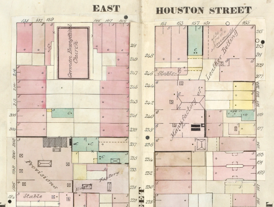
Not only can we see exact street numbers for each building, but the labels help explain non-residential buildings. We can see a German Evangelical Church, a wagon factory, a leather belt manufactory, and more.
Many of these maps can be downloaded as .kmz files and loaded into Google Earth. When overlaid on top of an ancestor's exact address, this can help paint a very accurate picture of their neighborhood and help us locate new records. In the above example, the German Evangelical Church in this neighborhood would be a great place to begin looking for baptism, marriage, or other religious records.
Even beyond that, we can use this information to color a narrative. Imagine being able to write—with completely accurate historical detail—what kinds of buildings and shops our ancestors passed as they walked down the street. That's the kind of information and detail that can get others very excited about reading and exploring family history.
Conclusion: Try it yourself!
We hope this blog has given you a few ideas - now it’s time to go out and try it yourself!
- Download Google Earth Pro and watch some of the tutorials.
- Download the historical county boundaries for New York and load them into the program.
- Download some topographical or urban maps of interest and load them into the program.
Remember, the techniques outlined in this article become even more meaningful if you have already plotted some of your own family history information on the Google Earth map. If you haven’t done that, revisit part 1 of this article series to learn more.
Good luck mapping!
Learn More
-
Google Earth for Genealogy, Part 1: Putting Your Ancestors on the Map
-
Historical New York Maps for Genealogy Research
-
Why and How New Yorkers Migrated to the Great Plains
-
New York vital records timeline: Key dates that impact your research
-
New online: Find a photo of any NYC building from 1940
-
Finding Birth, Marriage, and Death Records in New York State